It looks like the Santa Fe fires, Tres Lagunas and Thompson Ridge, are mostly under control. There are two lightning-starts further up in the Pecos Wilderness to the north and east, Jaroso (on Pecos Baldy) and White's Peak (14 miles Southwest of Cimarron, NM) which seem to be in let-it-burn mode because they are very remote and no structures are threatened. Plus the Silver fire just northeast of Silver City which is still very active. You can see all these on this map:
http://gacc.nifc.gov/swcc/predictive/intelligence/admin/google_maps/ics_209_incidents/ics_209_incidents.htm
For some reason InciWeb and NMfireInfo have just ignored White's Peak and are not updating Jaroso very clearly, so that map is the best I can find.
Also here's an interesting video produced by the Colorado Springs Fire Department which shows how they are protecting homes in the path of the Black Forest fire which has whacked over 480 structures and 14,000 acres so far:
http://vimeo.com/68342641
Since this blog is a Google production and the video is not on UTub the point and click integration is minimal, so you will just have to follow the link...The Inter-tube-world is now in a three-way polarization war (MicroSlop vs GooglePlex vs Awpple) being fought via the proxies of difficult cross linking and non-integration. But that's Our Modern Life.
Showing posts with label firefighter. Show all posts
Showing posts with label firefighter. Show all posts
Monday, June 17, 2013
Tuesday, June 4, 2013
Fire News
Cannon to right of them,
Cannon to left of them,
Cannon behind them
Volley'd & thunder'd
With the sound of a Sikorski chopper headed to Pecos in the background here's some information about our first round of summer fires here in lovely downtown Northern New Mexico...
We have two incidents, each well into a week long. To the West of Santa Fe in the Jemez mountains, the Thompson Ridge fire is at about 4500 acres and moving East towards the Valdes Caldera where the Los Conches fire did its damage two years ago. Just North of Pecos, NM to the East in the Sangres, the Tres Lagunas fire is pushing 8700 acres moving mostly uphill to the North. One can find the latest information, updated once or twice a day, at NMfireinfo.com which also features a twitter sidebar that often links to newer postings. The forest service also maintains a Google Earth map of incidents throughout the entire country at: http://activefiremaps.fs.fed.us/googleearth.php. But here's the latest maps that I've found posted:
Thompson Ridge from June 3 at 20:51:
 For reference here's the Google Map of about the same area,
centered at 35 53 00N 106 36 30W:
View Larger Map
Tres Lagunas from Jun 3 at 21:07, heat map:
 and fire progression:
 And again, for reference here's the Google Map of about the same area,
centered at 35 43 00N 105 39 00W:
View Larger Map
Thompson Ridge from June 3 at 20:51:
centered at 35 53 00N 106 36 30W:
View Larger Map
Tres Lagunas from Jun 3 at 21:07, heat map:

centered at 35 43 00N 105 39 00W:
View Larger Map
Hopefully the left hand will not meet up with the right hand.
Sunday, April 1, 2012
Local Color VIII -- Kinks in da'Hood
By a process of default thinking I declined to respond to a medical call at 01:45 Saturday morning -- one of those, "The go-getters will go get it," things. It turns out to be a wise decision because there were shots-and-tasers-fired and our Med unit wasn't released until 08:00, so everyone got to stay up all night waiting for the taser barb removal ritual. This all happened in my neighborhood, which, combined with multiple recent calls further down the street to transport intoxicated inhabitants to rehab, is making my colleagues in the VFD a bit suspicious of my general geographic sanity level...
Case #0212004766 -- 03-31-2012
Location: E. Sunlit, Seton Village area, Santa Fe, NM
Arrested: Charges pending, name witheld for actve/on-going investigation
On Sunday March 31, 2012 at 1:43 am Santa Fe County Sheriff's Deputies received a call for service in regards to a suicidal female. Santa Fe County Sheriff's Deputies arrived on scene and the suicidal female barricaded herself in the residence with a small, black in color, semi automatic handgun. Deputies attempted to negotiate with the female to surrender the weapon and come out of the residence. The female was not complying with any verbal commands at which time Santa Fe County Sheriff's Deputies encountered the female in a hallway pointing the weapon at them. Santa Fe County Sheriff's Deputies advised the female to drop the weapon and the female wouldn’t. One shot was fired by a Santa Fe County Sheriff's Deputy, not striking the female, and the female sought cover within a bedroom.
Santa Fe County Sheriff's Office S.W.A.T. Team was activated and arrived at the scene. The female was still irrational and not complying with any verbal commands. The female demanded her purse be brought to her and Santa Fe County S.W.A.T. complied with the demand. The female attempted to retrieve the purse from the porch at which time Santa Fe County S.W,A.T. implemented the use of a Taser. The female was struck with the Taser and then taken into custody without incident at 7:40 am on today's date.
The female was transported to Christus St. Vincent's Hospital for a mental evaluation where she currently remains with an involuntary hold for observation. This case is under investigation and charges are pending.
Case #0212004766 -- 03-31-2012
Aggravated Assault On A Law Enforcement Officer and Mental Evaluation Hold
Location: E. Sunlit, Seton Village area, Santa Fe, NMArrested: Charges pending, name witheld for actve/on-going investigation
On Sunday March 31, 2012 at 1:43 am Santa Fe County Sheriff's Deputies received a call for service in regards to a suicidal female. Santa Fe County Sheriff's Deputies arrived on scene and the suicidal female barricaded herself in the residence with a small, black in color, semi automatic handgun. Deputies attempted to negotiate with the female to surrender the weapon and come out of the residence. The female was not complying with any verbal commands at which time Santa Fe County Sheriff's Deputies encountered the female in a hallway pointing the weapon at them. Santa Fe County Sheriff's Deputies advised the female to drop the weapon and the female wouldn’t. One shot was fired by a Santa Fe County Sheriff's Deputy, not striking the female, and the female sought cover within a bedroom.
Santa Fe County Sheriff's Office S.W.A.T. Team was activated and arrived at the scene. The female was still irrational and not complying with any verbal commands. The female demanded her purse be brought to her and Santa Fe County S.W.A.T. complied with the demand. The female attempted to retrieve the purse from the porch at which time Santa Fe County S.W,A.T. implemented the use of a Taser. The female was struck with the Taser and then taken into custody without incident at 7:40 am on today's date.
The female was transported to Christus St. Vincent's Hospital for a mental evaluation where she currently remains with an involuntary hold for observation. This case is under investigation and charges are pending.
Sunday, January 15, 2012
3AM
I wrote this recently thinking I would enter an AARP volunteerism contest. It turned out they wanted a different kind of story (and the stupid entry website just ate my homework when I tried to apply) so I gave up. The actual event happened about a year ago, but we just had two more 3AM fire calls -- on which I demurred response -- so I think it describes the job reasonably well...
When my pager goes off at 3AM I am, uncharacteristically, sleeping rather soundly: "Vehicle fire, intersection of (two streets near my home)". I grumble and think, "Ah, the go-getter kids will go-get this one". But in fact the (two streets near my home) are between me and my Fire Station, so it really is My Neighborhood that needs help. I stumble on some clothes, retain my slippers because it's either a false alarm or I'll have to don my full bunkers -- fire gear and boots -- anyway, and get out the door in under five minutes. A couple minutes later I'm at the specified intersection and find nothing of interest. I radio this information to the dispatch center who reply, "The caller said at the end of (one of the streets near my home)". So. Hmm. Maybe it's the _other_ end?
For the last five years I've been a volunteer firefighter in an area of Urban-Wildland Interface bisected by about 20 miles of Interstate Highway. Our district covers 120 square miles and has a population of 6000 people. The week after I signed on there was a multiple casualty highway accident involving a family of five. During the -- very detailed -- post incident review I thought, "You know, this might not be for me...". But through a series of fortuitous coincidences I persevered and now have Hazmat, Structural and Wildland Fire, and Medical First Responder certificates. I can also dismantle your car in about ten minutes if you are trapped inside. And I can drive with Lights'n'Sirens. In my own Personally Operated Vehicle even.
This being Urban-Wildland Interface territory the other end of my street is a mile and a half away around two hills. I U-turn and head back whence I came. Other folks responding are reporting that they see flames somewhere near my hill. So this is a real fire. Someplace nearby.
About 50% of our calls are medical and 20% are fires that don't exist. Two of the 300 fire alarm checks we've had in the last five years were actual fires. One was because the flue in the fireplace had fallen closed and the other was a pot of forgotten eggs boiling on the stove. There have also been a few well-done Thanksgiving turkeys to deal with. In those years we've lost two structures. One due to a wildland fire that took most of the County to control. Overall we've been very lucky. Really.
Fire trucks are spreading out in a somewhat directed search pattern as I make my way through the hills to the other-end-of-the-street. At the end I find a pickup truck in flames, "Fully Involved". Coming closer I see a body face down on ground near the driver's side, twitching as if it were attached to an electric line. I think, "WTF? Gangs? Up Here?" But I have the presence of mind to get on the radio and report what I see, and more importantly: Where I am. Now at least everyone else can find us.
I join forces with another of our guys who followed me up the hill and drag the "patient" away from the burning vehicle. The fire is spreading to the surrounding brush so I return to my truck to direct the rest of the cavalry to the scene and get suited-up for battle.
Then I stand there for what seems like an hour wondering, "Where the 'heck' is everyone?"
Finally our fire engine arrives. I pull a hose line and extinguish the brush fire while others get geared up and deal with the vehicle. It's all over in a few moments. Discounting the panic.
The patient turned out to be one of our own guys who had, shall we say, over-extended himself and decided that his exit strategy should be immediate. In a moment of clarity he radioed-in the location of his fire, which our dispatchers then slightly misinterpreted. Our department's participation in his initial group therapy sessions kind of overwhelmed the counseling facility. But he's doing fine now.
Tuesday, November 8, 2011
Now for a little change of pace...
We had our first significant snowfall last night. Not much and mostly melted off by now...but...up in the hills, in our Urban Wildland Interface Zone, things get pretty dicey pretty quick because there's no direct sunlight until summer.
So... Around noon today someone coming down the hill managed to drive off the road. By off-roading I mean down a steep embankment end-over-end for at least 100 yards, coming to rest -- fortunately -- on his wheels about 100 yards from another -- fortunately -- more accessible road. Unfortunately the vehicle was not visible through the dense vegetation from either vantage, but -- fortunately again -- the guy he hit on his way down was able to point out where it happened.
After about a half-hour of hiking around and yelling to each other we found the car and patient, who, thanks to modern vehicle restraint systems was not seriously injured and had better vital signs then me. Our medics packaged him up on a backboard in a stokes litter and we belayed him down the rest of the embankment that he hadn't managed to negotiate with his vehicle and onto a Big Wheel. The Big Wheel is exactly that, a Big Wheel with a bunch of handles onto which you strap a litter, so 4 or 6 folks can hump a patient out of some god-forsaken location (we used it this summer to get a guy having a heart attack an hour into a National Forest trail back to civilization-such-as-it-is because the chopper couldn't find anywhere to land).
We loaded the patient into a City of Santa Fe Med unit -- our County guys were busy and probably kicking themselves for missing the fun -- and shipped him off to the Horsepiddle. I'll bet the City guys were happy about the Big Wheel thing, but they are too professionally pre-occupied to thank mere volunteers.
Way better than doing homework, to which I must now return...
So... Around noon today someone coming down the hill managed to drive off the road. By off-roading I mean down a steep embankment end-over-end for at least 100 yards, coming to rest -- fortunately -- on his wheels about 100 yards from another -- fortunately -- more accessible road. Unfortunately the vehicle was not visible through the dense vegetation from either vantage, but -- fortunately again -- the guy he hit on his way down was able to point out where it happened.
 |
| Photo: Tom Chilton -- Hondo VFD |
After about a half-hour of hiking around and yelling to each other we found the car and patient, who, thanks to modern vehicle restraint systems was not seriously injured and had better vital signs then me. Our medics packaged him up on a backboard in a stokes litter and we belayed him down the rest of the embankment that he hadn't managed to negotiate with his vehicle and onto a Big Wheel. The Big Wheel is exactly that, a Big Wheel with a bunch of handles onto which you strap a litter, so 4 or 6 folks can hump a patient out of some god-forsaken location (we used it this summer to get a guy having a heart attack an hour into a National Forest trail back to civilization-such-as-it-is because the chopper couldn't find anywhere to land).
We loaded the patient into a City of Santa Fe Med unit -- our County guys were busy and probably kicking themselves for missing the fun -- and shipped him off to the Horsepiddle. I'll bet the City guys were happy about the Big Wheel thing, but they are too professionally pre-occupied to thank mere volunteers.
Way better than doing homework, to which I must now return...
Sunday, October 2, 2011
Natural Stupidity (not Artificial Intelligence)
Did a Faceplant from a Firetruck yesterday. Fortunately it was during a training so everything could grind to a halt while they prepped me for the required ambulance ride to the ER...
We were pulling the supply hose from the roof bed of the tanker when it got hung up someplace. So I climbed up a couple steps on the back of the truck to see what was what. I pulled. Nada. I pulled real-way-more harder and the hose gave way suddenly causing me to lose my grip -- as if I hadn't already -- and fly off the steps. I performed a perfect three point landing in the gravel on my hands and face. Did the Klingon modifications to my face as shown, stained my neck, and compressed both wrists, but only bruised one palm.
I was not wearing my helmet, which might have protected my face at the expense of breaking my neck, so I guess inattention to detail is sometimes useful.
 my own work |
 after they were finished |
 later that day |
 24 hours in |
We were pulling the supply hose from the roof bed of the tanker when it got hung up someplace. So I climbed up a couple steps on the back of the truck to see what was what. I pulled. Nada. I pulled real-way-more harder and the hose gave way suddenly causing me to lose my grip -- as if I hadn't already -- and fly off the steps. I performed a perfect three point landing in the gravel on my hands and face. Did the Klingon modifications to my face as shown, stained my neck, and compressed both wrists, but only bruised one palm.
I was not wearing my helmet, which might have protected my face at the expense of breaking my neck, so I guess inattention to detail is sometimes useful.
Sunday, July 17, 2011
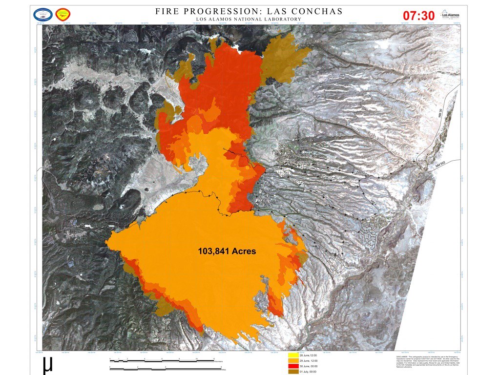
Las Conches Endgame?
Here's what it looked like from my place on the evening of July 15:

The plume, at the southern end of the fire in the map below, is about due west and Los Alamos is just off the right edge of the photo -- which may give some idea of scale and relative position. Also, for scale, the burned area in this map is about 230 square miles....
 I think much of the smoke we've seen since Friday is from back-burns meeting up with the real fire. On Monday S.Fe county is sending one of Hondo's brush trucks with a "foreign" (not of Hondo) crew up to help with mopup.

The plume, at the southern end of the fire in the map below, is about due west and Los Alamos is just off the right edge of the photo -- which may give some idea of scale and relative position. Also, for scale, the burned area in this map is about 230 square miles....

Wednesday, July 6, 2011
More Fire Stuff
Tom Ashcraft over at heliotown.com sent me this time-lapse video from the first night of the Las Conches fire. It's from just east of Eldroado (a few miles down the road from me) and he says it was shot with a standard lens -- not a telephoto -- but it seems up pretty close when compared to my previously posted deck photos. I musta missed the big overture...

Tuesday, July 5, 2011
All Along the Watchtower
Last night everyone in the greater Santa Fe area had a devilish view of three or four Las Conches ridgelines happily burning away. One way to the south above Cochiti and the others behind and above Los Alamos. That and concentrated fire-truck patrols seems to have put a damper on private aerial fireworks displays down here, so we had no real incidents with which to deal -- in my district, Hondo, the guys mostly drove around to get different and better views of the burning ridges to the west. There was apparently one rough moment elsewhere in the county when an off duty State Police Personage refused to stop celebrating -- who do you call then, the FBI?
Anyway here's today's map showing growth to the north. Some theories have it running until it gets to Abiquiu, quite a bit further north. And, based on yesterday's personal communications, it is also still burning down the canyons of Santa Clara, destroying most of the watershed for the Pueblo. Hopefully they will be able to recover in a timely manner:

Here is a map from the night of July 3rd which shows the daily size increase. Very impressive:

Anyway here's today's map showing growth to the north. Some theories have it running until it gets to Abiquiu, quite a bit further north. And, based on yesterday's personal communications, it is also still burning down the canyons of Santa Clara, destroying most of the watershed for the Pueblo. Hopefully they will be able to recover in a timely manner:
Here is a map from the night of July 3rd which shows the daily size increase. Very impressive:

Sunday, July 3, 2011
Pacheco Fire -- the ignored eldest child
So what's happened to the Pacheco Fire during all this excitement about Las Conches? Fortunately not much of the bad type...it seems to be fairly contained and -- weather willing -- not spreading. Incident Command is being transferred to local authorities which means that it's mostly grunt work, a LOT of grunt work, left to do. I found this June 26 satellite image of the two fires on NASA's Earth Observatory. I didn't realize that they are directly across the Rio Grande from each other:
(NASA doesn't seem to put images on this site in a timely manner so you can't use it to track reality, but they are instructive none-the-less).
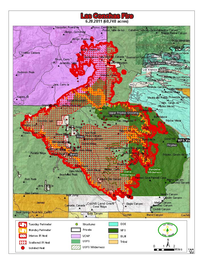
Getting back to Las Conches, it too seems to be in the wind-down phase. No fat ladies are singing (outside of the opera house) yet, but Los Alamos and LANL are off evacuation notice. Yesterday an actual good map was posted and I grabbed a copy in case it got disappeared. Unfortunately it's embeded in a pdf document as small strips of image so you'll just have to download it and look at it as best you can: http://www.etantdonnes.com/HVFD/image/lasconches_ftp-20110701-153027.pdf. By comparing that map to the usual-schmutzy one from July 2 23:00 posted this morning you can get an idea of what's been affected and where -- it is hoped -- it will all end:

A number of people have asked me, "How come they don't just fill up every airplane and drown the thing right away?" The problem is, you can't get enough water in the air to have any real effect. Let's just say that it would take a storm dumping 1" of rain in an hour to knock-down a square-mile of burning forest -- I'm just grabbing those numbers out of an orifice, but I think they're in the right ballpark. That storm would deliver around 18 million gallons of water. Most firefighting air tankers carry 3000 gallons or less, so you would need to execute 6000 drops in an hour to have the same effect. Thus air drops are generally used on small spot fires or to create containment lines with retardant.
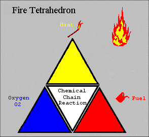
Which brings me to a small lecture on wildfire fighting. The Fire Tetrahedron shows that you need four things for a fire to burn: Air, Fuel, Heat, and Chemistry. To stop the fire you need to interrupt continuity in one or more of those. For a structure fire you have a failrly well contained but very hot fire. You can deliver 10 or 20,000 gallons of water in an hour and basically drown it -- the water cools it off and to some extent limits the fuel's access to air. In a big wildland fire there's no way to cool it off, so the only thing you can do is limit it's access to fuel. This is called "cutting line" around the fire. We have to make a break in the continuity of fuel using natural barriers like ridge-tops and rivers as well as man-made roads, bull-dozed strips, and, very often, hand-dug trenches.
The three things of interest in a widlfire are: Fuel, Weather, and Topology. With heavy fuels -- big trees with jungle-like understory -- it's very hard to break the continuity. Windy, especially hot and dry, weather drives the fire and causes "spotting" -- embers blown far from the fire front which ignite new "spot fires" that can expand and spot some more. Rough terrain makes it very hard to access to cut-line and, since fire likes to travel up, the second worst place to be (the worst being IN the fire) is up-wind and up-hill -- which is exactly where you need to be in order to stop the main fire's progress and knock out those small spot fires. That's why these things take so long to get under control.
For Las Conches, it looks like really concentrated work saved the Pajarito Ski lodge buildings and, with some added weather luck, kept the fire from spreading into inhabited parts of Los Alamos. But that's using over 1000 people on only a small part of the fire-line.
Personal interest aside: I grew up near the SoCal air tanker base which this guy visited: Cal Fire Airtankers at Hemet-Ryan,CA so I well remember them flying overhead all day long during the summer.
 link
link(NASA doesn't seem to put images on this site in a timely manner so you can't use it to track reality, but they are instructive none-the-less).
Getting back to Las Conches, it too seems to be in the wind-down phase. No fat ladies are singing (outside of the opera house) yet, but Los Alamos and LANL are off evacuation notice. Yesterday an actual good map was posted and I grabbed a copy in case it got disappeared. Unfortunately it's embeded in a pdf document as small strips of image so you'll just have to download it and look at it as best you can: http://www.etantdonnes.com/HVFD/image/lasconches_ftp-20110701-153027.pdf. By comparing that map to the usual-schmutzy one from July 2 23:00 posted this morning you can get an idea of what's been affected and where -- it is hoped -- it will all end:

A Little Exegesis
A number of people have asked me, "How come they don't just fill up every airplane and drown the thing right away?" The problem is, you can't get enough water in the air to have any real effect. Let's just say that it would take a storm dumping 1" of rain in an hour to knock-down a square-mile of burning forest -- I'm just grabbing those numbers out of an orifice, but I think they're in the right ballpark. That storm would deliver around 18 million gallons of water. Most firefighting air tankers carry 3000 gallons or less, so you would need to execute 6000 drops in an hour to have the same effect. Thus air drops are generally used on small spot fires or to create containment lines with retardant.
Which brings me to a small lecture on wildfire fighting. The Fire Tetrahedron shows that you need four things for a fire to burn: Air, Fuel, Heat, and Chemistry. To stop the fire you need to interrupt continuity in one or more of those. For a structure fire you have a failrly well contained but very hot fire. You can deliver 10 or 20,000 gallons of water in an hour and basically drown it -- the water cools it off and to some extent limits the fuel's access to air. In a big wildland fire there's no way to cool it off, so the only thing you can do is limit it's access to fuel. This is called "cutting line" around the fire. We have to make a break in the continuity of fuel using natural barriers like ridge-tops and rivers as well as man-made roads, bull-dozed strips, and, very often, hand-dug trenches.
The three things of interest in a widlfire are: Fuel, Weather, and Topology. With heavy fuels -- big trees with jungle-like understory -- it's very hard to break the continuity. Windy, especially hot and dry, weather drives the fire and causes "spotting" -- embers blown far from the fire front which ignite new "spot fires" that can expand and spot some more. Rough terrain makes it very hard to access to cut-line and, since fire likes to travel up, the second worst place to be (the worst being IN the fire) is up-wind and up-hill -- which is exactly where you need to be in order to stop the main fire's progress and knock out those small spot fires. That's why these things take so long to get under control.
For Las Conches, it looks like really concentrated work saved the Pajarito Ski lodge buildings and, with some added weather luck, kept the fire from spreading into inhabited parts of Los Alamos. But that's using over 1000 people on only a small part of the fire-line.
Personal interest aside: I grew up near the SoCal air tanker base which this guy visited: Cal Fire Airtankers at Hemet-Ryan,CA so I well remember them flying overhead all day long during the summer.
Friday, July 1, 2011
July 1 and Counting
Today's map. The brown areas are the expansion over the last day mostly to the north and into Santa Clara land. The rain helped a bit, but is predicted to dry out by this afternoon. I found this on http://twitter.com/#!/NMFireInfo/lasconchasfire, posted by someone from LANL but not on the inciweb site (yet?):

The Las Conches Fire is now the largest wildfire on record in New Mexico. But we have a contender. The Donaldson Fire, down south of the other Hondo, NM, is racking up the tall-grass acreage at close to 80,000 today.
The Las Conches Fire is now the largest wildfire on record in New Mexico. But we have a contender. The Donaldson Fire, down south of the other Hondo, NM, is racking up the tall-grass acreage at close to 80,000 today.
Thursday, June 30, 2011
Las Conches June 30
Another small-n-schmutzy map from the forest service. More growth to the north and it's spread onto sacred Santa Clara tribal land:
 The ominous black fingers around Los Alamos are the past Cerro Grande fire boundaries, so actually a good thing as that area was recently burned out and less likely to go full bore again.
Having the first cats-n-dogs rain here at EarthSchip right now, so maybe relief is on the way.
I mycells spent all day at the Toyota dealership waiting for Bubba-San's brake$$ to be fixed, so again all work and no play for the dull boy.
Having the first cats-n-dogs rain here at EarthSchip right now, so maybe relief is on the way.
I mycells spent all day at the Toyota dealership waiting for Bubba-San's brake$$ to be fixed, so again all work and no play for the dull boy.
Wednesday, June 29, 2011
Las Conches June 29
New day, new map. For some reason they have this posted on NMFireInfo in a tiny little ever-changing window so you can't recognize anything and it changes to a slightly different version before you realize you don't know what it means. I found that if you "View Image" and then hack off the excess from the jpg URL you get a bigger map. This for instance (click for more):

Looks like it's still sneaking up on LANL and almost has the Pajarito Ski Area surrounded, but grew more to the north and south. Right now I can see a goodly plume from what must be the Bandelier burn on the south-east side. And the wind seems to be picking up from the west again
We'll just see.
Looks like it's still sneaking up on LANL and almost has the Pajarito Ski Area surrounded, but grew more to the north and south. Right now I can see a goodly plume from what must be the Bandelier burn on the south-east side. And the wind seems to be picking up from the west again
We'll just see.
Tuesday, June 28, 2011
Las Conches June 28
The wind changed last night for a bit and it looks like it blew the fire to the north instead of into Los Alamos. It did grow a bit to the east and if the wind changes back to from-the-west Trouble could lie ahead:
 Here's approximately the same thing on Google Maps where the confluence of the blue-green areas in the upper right above is the intersection of highways 4 and 501 marked with the arrow. (For some reason I don't seem to be smart enough to embed the map here, so you'll have to point'n'click).
The Santa Fe County Fire Dept has deployed one wildland and three structural engine crews (all volunteers, although I think they will get paid eventually) in mutual aid. Fortunately I'm too weak and infirm to participate, but someone has to hang around the station here just in case....
The Santa Fe County Fire Dept has deployed one wildland and three structural engine crews (all volunteers, although I think they will get paid eventually) in mutual aid. Fortunately I'm too weak and infirm to participate, but someone has to hang around the station here just in case....
Monday, June 27, 2011
Las Conchas Wildfire...better map
My fire chief just sent a better image of the map I posted. It's from IR mapping this morning at about 03:00 June 27:


I was right about Hwy 4 being the north boundary. Los Alamos is just beyond the top-right corner and the Rio Grande cuts across at the bottom-left corner. It's spotting (those little dots) to the south-east whereas the wind yesterday seemed to be from the south-west, maybe it was from the west...
Las Conchas Wildfire
So we have a second fire going. This one is in the Jemez Caldera -- across the way from the Sangre de Cristo's Pacheco fire -- and down wind of Los Alamos. The good thing is that the 2000 Cerro Gordo fire burned out a bit of the intervening land. The bad thing is that thunder storms -- not showers -- are predicted for the rest of the week.
I finally got around to shooting a little video of my UndMill on the deck around noon yesterday and then went out to lunch. The new fire started smack in the background of my video, so I guess it's my fault somehow. Here's the plume at around sunset last night (20:00, June 26) after it had burned for 6 or 7 hours, the sun is directly behind the smoke, more or less west-north-west from my house:


This morning it was within one mile of the first LANL buildings. This is a mostly useless map from the NM Fire Info site. I can't distinguish any landmarks except I think the north side is along Highway 4 and Los Alamos is somewhere just off the east (right) side:

In the event that some dipwit tosses a cig out the window on any of the roads near my house I packed a bag and put the bunny on notice that he might be subject to a grab-and-run operation...backing up data now.
I finally got around to shooting a little video of my UndMill on the deck around noon yesterday and then went out to lunch. The new fire started smack in the background of my video, so I guess it's my fault somehow. Here's the plume at around sunset last night (20:00, June 26) after it had burned for 6 or 7 hours, the sun is directly behind the smoke, more or less west-north-west from my house:
And here's what it looked like around midnight. Flames were just cresting the ridgeline above Bandelier on the other side of the Rio Grande river. Los Alamos is off to the right about 3 more fire-lengths, where I estimate a "fire-length" to be about three miles:
This morning it was within one mile of the first LANL buildings. This is a mostly useless map from the NM Fire Info site. I can't distinguish any landmarks except I think the north side is along Highway 4 and Los Alamos is somewhere just off the east (right) side:
In the event that some dipwit tosses a cig out the window on any of the roads near my house I packed a bag and put the bunny on notice that he might be subject to a grab-and-run operation...backing up data now.
Saturday, June 25, 2011
Pacheco Fire
This last week, because the smoke cleared from Arizona's Wallow fire, we've been having our own little party in the Santa Fe National Forest. (un)Fortunately it's on Forest Service land so most of the S.Fe City and County folks don't get to play -- the county Black Canyon Handcrew responded on the first day, but I'm not sure they are still deployed. It started around the far reaches of the Borrego Trail where the power lines cross and is traveling up the north face of Santa Fe Baldy -- away from town if the winds hold from the SW. It's on really rugged terrain so access is limited to very healthy hikers. Over 600 personnel are deployed and their base camp is in the muni-rec-area out west of town by the dump. A dust devil blew through yesterday and took out the mess tent. It could be the Rapture, as promised.
Anyway, it ain't goin out until the rains come. Pretty much all the fire-fighters can do is try to contain it by "cutting-line" and "burning-out" in it's path and hope that it doesn't throw spots further than can be reached in time.
I've been taking a picture around 4 or 5 pm every day or so, pretty much directly north from my house but I have to walk around the intervening hillock to get the view. This one is June 18 a couple hours after it started. Notice the black, heavy-fuel driven plume on the left:

Then June 19, it looked like it might be calming down a b it:

And on June 23, maybe it's sorta under control?

Nope. Today, June 25, it seems to be rip-roaring again:

Fire information, such as it is, for larger wildland fires in New Mexico can be found on NM Fire Info and somewhat more extensive data for National Forest incidents in NM is on InciWeb which sometimes also has a useful map.
Now we're waiting for the Fourth of July fireworks extravaganza.
Saturday, June 11, 2011
Career Ending Moves
Wednesday night -- after spending 4 hours driving a tanker around a burned field east of Stanley in the dark -- I realized that by moving to S.Fe I initiated a career ending trifecta:
In order to cement #3 above I have written a second-opinion review of The Due Return, S.Fe's Summer Rave Installation: Lost in Space-Time -- A D-Ticket Ride. I'll never work in this town again.
In trade I have met a few [emphasis added] new and lovely friends, gained a food-snob rabbit companion, and become a volunteer fire-fighter. In the summer when the wind is not howling it sometimes seems worth it.
- No more software engineering (took one year and good riddance)
- Failed at robot research (took five years and too bad)
- Complete disconnect from the art/sci/tech world (took ten years and who cares)
In order to cement #3 above I have written a second-opinion review of The Due Return, S.Fe's Summer Rave Installation: Lost in Space-Time -- A D-Ticket Ride. I'll never work in this town again.
In trade I have met a few [emphasis added] new and lovely friends, gained a food-snob rabbit companion, and become a volunteer fire-fighter. In the summer when the wind is not howling it sometimes seems worth it.
Subscribe to:
Comments (Atom)