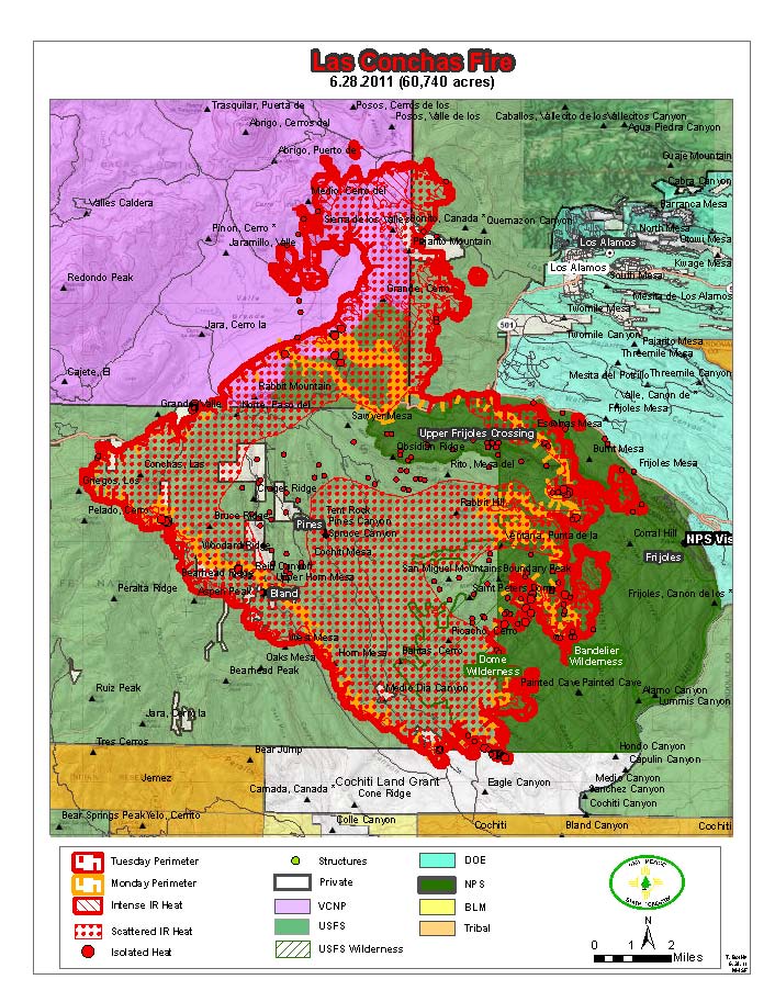
Another small-n-schmutzy map from the forest service. More growth to the north and it's spread onto sacred Santa Clara tribal land:
The ominous black fingers around Los Alamos are the past Cerro Grande fire boundaries, so actually a good thing as that area was recently burned out and less likely to go full bore again.
Having the first cats-n-dogs rain here at EarthSchip right now, so maybe relief is on the way.
I mycells spent all day at the Toyota dealership waiting for Bubba-San's brake$$ to be fixed, so again all work and no play for the dull boy.
Thursday, June 30, 2011
Wednesday, June 29, 2011
Las Conches June 29
New day, new map. For some reason they have this posted on NMFireInfo in a tiny little ever-changing window so you can't recognize anything and it changes to a slightly different version before you realize you don't know what it means. I found that if you "View Image" and then hack off the excess from the jpg URL you get a bigger map. This for instance (click for more):
Looks like it's still sneaking up on LANL and almost has the Pajarito Ski Area surrounded, but grew more to the north and south. Right now I can see a goodly plume from what must be the Bandelier burn on the south-east side. And the wind seems to be picking up from the west again
We'll just see.
Looks like it's still sneaking up on LANL and almost has the Pajarito Ski Area surrounded, but grew more to the north and south. Right now I can see a goodly plume from what must be the Bandelier burn on the south-east side. And the wind seems to be picking up from the west again
We'll just see.
Tuesday, June 28, 2011
Las Conches June 28
The wind changed last night for a bit and it looks like it blew the fire to the north instead of into Los Alamos. It did grow a bit to the east and if the wind changes back to from-the-west Trouble could lie ahead:
Here's approximately the same thing on Google Maps where the confluence of the blue-green areas in the upper right above is the intersection of highways 4 and 501 marked with the arrow. (For some reason I don't seem to be smart enough to embed the map here, so you'll have to point'n'click).
The Santa Fe County Fire Dept has deployed one wildland and three structural engine crews (all volunteers, although I think they will get paid eventually) in mutual aid. Fortunately I'm too weak and infirm to participate, but someone has to hang around the station here just in case....
Here's approximately the same thing on Google Maps where the confluence of the blue-green areas in the upper right above is the intersection of highways 4 and 501 marked with the arrow. (For some reason I don't seem to be smart enough to embed the map here, so you'll have to point'n'click).
The Santa Fe County Fire Dept has deployed one wildland and three structural engine crews (all volunteers, although I think they will get paid eventually) in mutual aid. Fortunately I'm too weak and infirm to participate, but someone has to hang around the station here just in case....
Monday, June 27, 2011
Las Conchas Wildfire...better map
My fire chief just sent a better image of the map I posted. It's from IR mapping this morning at about 03:00 June 27:
I was right about Hwy 4 being the north boundary. Los Alamos is just beyond the top-right corner and the Rio Grande cuts across at the bottom-left corner. It's spotting (those little dots) to the south-east whereas the wind yesterday seemed to be from the south-west, maybe it was from the west...
Las Conchas Wildfire
So we have a second fire going. This one is in the Jemez Caldera -- across the way from the Sangre de Cristo's Pacheco fire -- and down wind of Los Alamos. The good thing is that the 2000 Cerro Gordo fire burned out a bit of the intervening land. The bad thing is that thunder storms -- not showers -- are predicted for the rest of the week.
I finally got around to shooting a little video of my UndMill on the deck around noon yesterday and then went out to lunch. The new fire started smack in the background of my video, so I guess it's my fault somehow. Here's the plume at around sunset last night (20:00, June 26) after it had burned for 6 or 7 hours, the sun is directly behind the smoke, more or less west-north-west from my house:
This morning it was within one mile of the first LANL buildings. This is a mostly useless map from the NM Fire Info site. I can't distinguish any landmarks except I think the north side is along Highway 4 and Los Alamos is somewhere just off the east (right) side:
In the event that some dipwit tosses a cig out the window on any of the roads near my house I packed a bag and put the bunny on notice that he might be subject to a grab-and-run operation...backing up data now.
I finally got around to shooting a little video of my UndMill on the deck around noon yesterday and then went out to lunch. The new fire started smack in the background of my video, so I guess it's my fault somehow. Here's the plume at around sunset last night (20:00, June 26) after it had burned for 6 or 7 hours, the sun is directly behind the smoke, more or less west-north-west from my house:
And here's what it looked like around midnight. Flames were just cresting the ridgeline above Bandelier on the other side of the Rio Grande river. Los Alamos is off to the right about 3 more fire-lengths, where I estimate a "fire-length" to be about three miles:
This morning it was within one mile of the first LANL buildings. This is a mostly useless map from the NM Fire Info site. I can't distinguish any landmarks except I think the north side is along Highway 4 and Los Alamos is somewhere just off the east (right) side:
In the event that some dipwit tosses a cig out the window on any of the roads near my house I packed a bag and put the bunny on notice that he might be subject to a grab-and-run operation...backing up data now.
Saturday, June 25, 2011
Pacheco Fire
This last week, because the smoke cleared from Arizona's Wallow fire, we've been having our own little party in the Santa Fe National Forest. (un)Fortunately it's on Forest Service land so most of the S.Fe City and County folks don't get to play -- the county Black Canyon Handcrew responded on the first day, but I'm not sure they are still deployed. It started around the far reaches of the Borrego Trail where the power lines cross and is traveling up the north face of Santa Fe Baldy -- away from town if the winds hold from the SW. It's on really rugged terrain so access is limited to very healthy hikers. Over 600 personnel are deployed and their base camp is in the muni-rec-area out west of town by the dump. A dust devil blew through yesterday and took out the mess tent. It could be the Rapture, as promised.
Anyway, it ain't goin out until the rains come. Pretty much all the fire-fighters can do is try to contain it by "cutting-line" and "burning-out" in it's path and hope that it doesn't throw spots further than can be reached in time.
I've been taking a picture around 4 or 5 pm every day or so, pretty much directly north from my house but I have to walk around the intervening hillock to get the view. This one is June 18 a couple hours after it started. Notice the black, heavy-fuel driven plume on the left:
Then June 19, it looked like it might be calming down a b it:
And on June 23, maybe it's sorta under control?
Nope. Today, June 25, it seems to be rip-roaring again:
Fire information, such as it is, for larger wildland fires in New Mexico can be found on NM Fire Info and somewhat more extensive data for National Forest incidents in NM is on InciWeb which sometimes also has a useful map.
Now we're waiting for the Fourth of July fireworks extravaganza.
Friday, June 24, 2011
A Modest Proposal
( I want to get this In Writing, Signed and Dated, so when someone finally does it we know I Thought of it First. This will subsequently be abbreviated and tagged: IWSDITIF).
I've had the idea to found an Art School for some time now. It should be in one of the downtrodden old-style cities, maybe Detroit? It would grant MFA degrees in all the usual suspect fields, drawing, painting, sculpture, music, new-media, performance, yada, de nada. It would have a residency program for one or more (funding dependent) recognized artists who would be selected by the student body, and maybe (again, funding dependent) a shorter duration visiting artist program. Small studio spaces and necessary equipment could be provided, sort of like the "maker-facilities" that are springing up in more populous regions.
The innovative features are:
I've had the idea to found an Art School for some time now. It should be in one of the downtrodden old-style cities, maybe Detroit? It would grant MFA degrees in all the usual suspect fields, drawing, painting, sculpture, music, new-media, performance, yada, de nada. It would have a residency program for one or more (funding dependent) recognized artists who would be selected by the student body, and maybe (again, funding dependent) a shorter duration visiting artist program. Small studio spaces and necessary equipment could be provided, sort of like the "maker-facilities" that are springing up in more populous regions.
The innovative features are:
- It would only offer classes in restaurant service and management;
- It would be funded by real-estate developers.
Subscribe to:
Posts (Atom)